Discovering Australia
Long before Captain Cook set foot on the shores of Australia on April 20, 1770, seafarers from the Old World had already landed here more than once.
Unknown Southern Continent
For the first time, the assumption that there is a continent in the Indian Ocean was made by Claudius Ptolemy. In the southern part of the map, which he placed in his work “A Guide to Geography”, you can see the coast of a land designated as Terra incognita, the Uncharted Land. To the west it was connected to Africa, and to the east to the Land of the Sins (southern China).
After Marco Polo’s discoveries, Europe learned that the Land of the Sines in the south does not merge with Terra incognita. After Vasco da Gama’s travels, it was clear that the southern tip of Africa was washed by water and did not pass into an unexplored continent either.
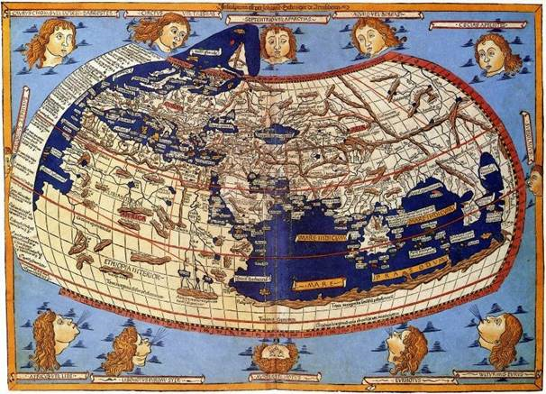
Map of Ptolemy. (wikipedia.org)
Expedition of Cristován de Mendonça
According to a number of historians, the Portuguese are the discoverers of Australia. It is believed that an expedition under the command of Cristován de Mendonça visited the northwest coast of the mainland in 1522. It is unclear whether this happened intentionally or accidentally. The details of this voyage are also unknown.
The only material evidence that has come down to us is small bronze cannons with the image of the Portuguese crown stamped on them, found in 1916 on the shores of Roebuck Bay (Western Australia). These artifacts date back to the early 16th century.
“Australia of the Holy Spirit”
When the Spanish completely conquered Peru in the 16th century, they attempted to establish a connection with the Philippines through the South Pacific. It was believed that the discovered New Guinea and Tierra del Fuego were peninsulas of an unknown continent. On the way from Peru towards the archipelago, the navigators encountered many unknown islands, each of which could be another peninsula of the new continent. The Spaniards called it Terra australis incognita – the Unexplored Southern Land.
In December 1605, an expedition of three ships under the command of Pedro Quiroz set out from Peru to the west. Over the course of a long voyage of a year, Kyros managed to discover several small islands in Southern Polynesia (the Tuamotu Archipelago).
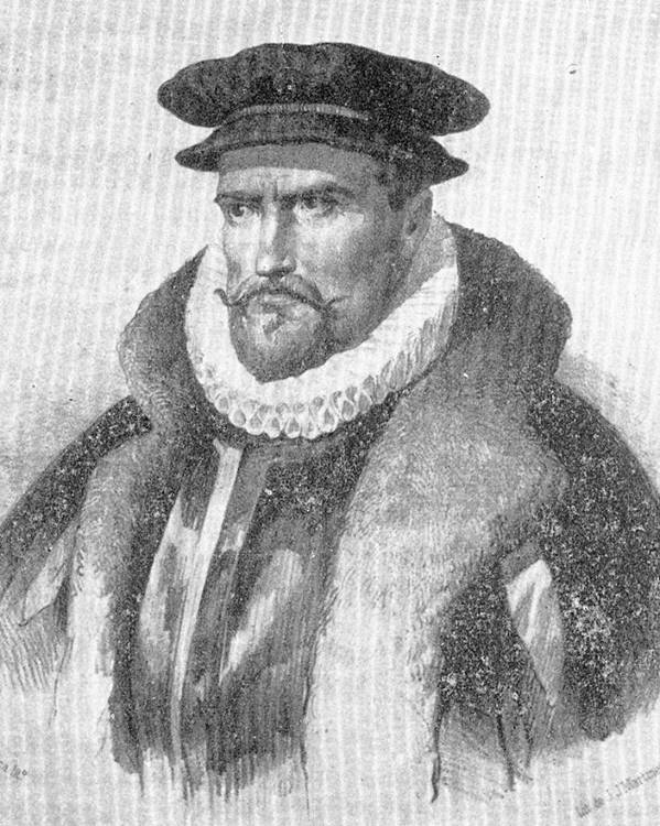
Pedro Fernández de Quirós. (wikipedia.org)
While staying on one of the inhabited islands of the Duff group, the travelers learned from the locals that there are several dozen small islands in the south, behind which there is a “big land”. Kyros set out in that direction the next day.
On April 27, the travelers did see the “mainland,” which seemed to stretch far to the southeast. Kyros thought he had reached the Southern Continent, which he called “Australia of the Holy Spirit.” Two years later, he described the discovered land to the king as follows: “In length it is greater than the whole of Europe and Asia Minor, taken within its boundaries up to the Caspian Sea and Persia, Europe with all the islands of the Mediterranean Sea and the Atlantic Ocean, including England and Ireland. This formerly hidden earth occupies a quarter of the world, and as such is twice as large as all the kingdoms and provinces which your Majesty possesses, and which God has vouchsafed you to possess hitherto.”
In fact, the land turned out to be an archipelago, later called the New Hebrides (the territory of the modern Republic of Vanuatu). This was confirmed by the two captains who accompanied Quirós on the expedition, Diego Prado y Tovar and Luis Vaez Torres. In June 1606, they explored the “mainland” more accurately and became convinced that Kyros had discovered not the southern continent, but a group of islands, and not very large ones.
First Landing in Australia
The first European to visit Australia is considered to be the Dutchman Willem Janszoon. He set sail on 28 November 1605 from Bantam on the ship Dufken. Circumnavigating the islands of Cai and Aru from the north, he reached the southern coast of New Guinea, which was completely unknown to the Dutch. Janszoon called it the “Swampy Land” and traced the coastline for 400 km. After rounding the island of Kolep, Janszoon turned southeast, crossed the central part of the Arafura Sea and suddenly saw the coast. It was Australia.
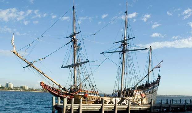
A replica of Dufken’s ship. (wikipedia.org)
In the western part of the Cape York Peninsula, near the mouth of a small river, in May 1606, the Dutch made the first documented European landing on the Australian continent. Janszoon steered his ship along a flat, deserted shore. Although the unknown land, as the Dutch were convinced, stretched further south, on June 6, 1606, at Cape Kerver (“The Turn”), the Dufken turned 180 degrees and set out on her return journey.
During the Albatross Bay landings, the Dutch first came into contact with the Australian Aborigines. A battle immediately ensued, and several people were killed on both sides. Continuing northward, the sailors traced and mapped the coast of the Cape York Peninsula almost to its northern tip. The total length of the explored coast of Australia, which Janszoon dubbed New Holland, was about 350 km.
Exploration of the mainland by the Dutch
The wreck of the English ship Triel, which occurred on May 25, 1622, on the reefs near the islands of Monte Bello and Barrow, showed that the complete unexplored waters washing the coast of Northwest and Northern Australia threaten great dangers. The leadership of the Dutch East India Company decided to explore the ocean south of Java and trace the southern coast of New Guinea. To accomplish this task, the expedition of Jan Carstens set out from Batavia in January 1623 on two ships, the Pera and the Arnhem.
For more than a week, Dutch sailors sailed along the southern coast of New Guinea. On the morning of February 16, Carstens saw a high mountain range in the distance—this was the western part of the Maoke Mountains. Five days later, a group of Dutchmen went ashore to replenish supplies. The local population was very hostile. As a result of the skirmish, 10 sailors were killed, including the captain of the Arnhem. On March 20, the expedition reached the southwestern tip of New Guinea.
The weather deteriorated, and a storm began. On 28 March, Carstens sent the navigator in a lifeboat with 12 sailors to explore the shore in the distance. They reported that the sea to the east was getting shallower, and in the distance they could see a desolate land. Meanwhile, it became dangerous to walk along the coast: shoals and reefs began to be encountered more and more often. The Dutch turned into the open sea. On April 12, land appeared on the horizon again. It was Australia. For two weeks, Carstens’ ships sailed south along the west coast of the Cape York Peninsula, landing several times at estuaries and bays.
The natives they met were quite peaceful. The flat and low-lying coast of Northwest Australia was described by Carstens in his report as “the most barren on Earth”. The Dutch couldn’t even find enough fresh water here. In addition, the expedition’s flagship, the Pera, was damaged. Carstens instructed Colster, captain of the Arnham, to complete the exploration of the coast, while he turned north and reached the Moluccas safely. Colster, moving south, managed to reach the Gulf of Carpentaria. Taking advantage of a favorable south-east monsoon, he turned north-west from here and, following this course, discovered a large peninsula, which was later named the Arnhemland Peninsula in honor of his ship.
Departure of the Dutch from the mainland
By the early 1640s, the Dutch knew and mapped the following parts of Australia: to the north, the west coast of the Cape York Peninsula, the Arnhamland salient, the entire west coast of the mainland, and the western part of its southern coast. However, it was still not clear what this mysterious land represented: a separate continent or a giant protrusion of the as yet undiscovered Great Southern Continent? And the pragmatic directors of the East India Company were also concerned with another question: What was the potential benefit of these newly discovered lands? What are their commercial prospects?
These questions were to be answered by the expedition of the Dutch navigator Abel Tasman, who left Batavia in 1642 on two small ships, the Hemskerk and the Zehan. Tasman did not encounter any mainland, and it was not until 24 November that he saw a high shore called Van Diemen’s Land (now Tasmania) from the Zehan. Tasman never knew whether it was an island or the southern tip of Australia, and Van Diemen’s Land was considered a peninsula for more than a century and a half until Bass Strait was passed. Moving further southeast, Tasman discovered New Zealand, and with that the expedition was almost over, leaving a lot of unsolved problems.
In 1645, the governor of Batavia, Van Diemen, sent Tasman on a new expedition to the shores of Australia. Three ships surveyed the southern coast of New Guinea for 750 km and completed the discovery of the Gulf of Carpentaria, circumnavigating its eastern shores and, for the first time, the southern and western shores. Experienced sailors, the Dutch never noticed the entrance to the Torres Strait.
In total, the expedition explored and mapped about 5,500 km of the coast and established that all the lands previously discovered by the Dutch are parts of a single continent – New Holland. However, Tasman found nothing noteworthy from the point of view of commerce on this continent, and after 1644 the Dutch completely cooled off to the Green Continent.
James Cook. Beginning of colonization
In 1768, James Cook set out on his first circumnavigation of the world. In April 1770 he approached Australia from the east. On the shore of the bay in which the Endeavour stopped, the expedition managed to find many previously unknown species of plants, so Cook called this bay the Botanical Bay.
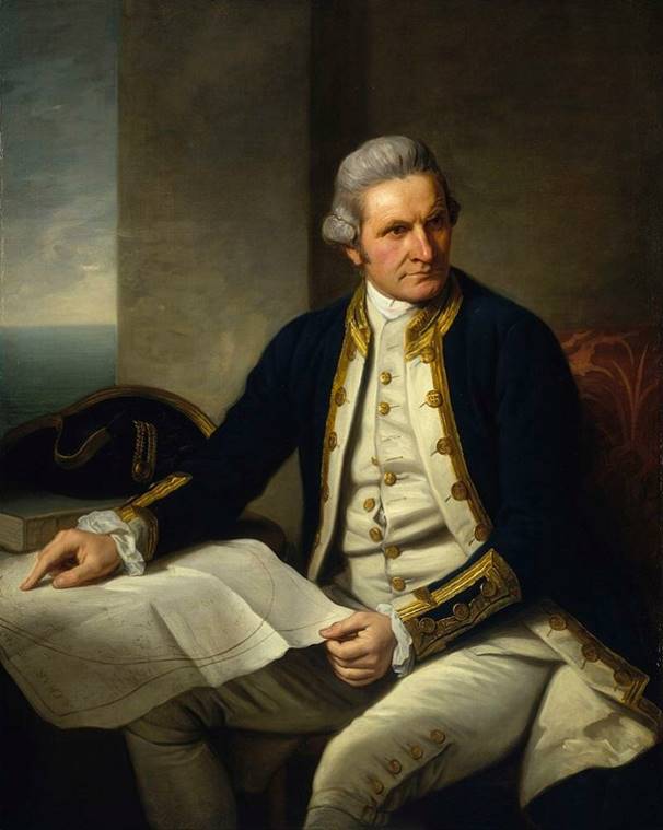
Portrait of James Cook, c. 1775 by Nathaniel Dance-Holland. (National Maritime Museum, London)
From here, the navigator headed northwest along the east coast. A few kilometers to the north Cook discovered a wide natural passage to a huge natural harbor, Port Jackson. In his report, the researcher described it as an ideal place for the safe mooring of many ships. Many years later, it was here that the first Australian city, Sydney, was founded.
It took Cook the next four months to climb up to the Gulf of Carpentaria, to the area called New Holland. The navigator made a detailed map of the coastline of the future Australia. After not exactly passing the Great Barrier Reef, the Endeavour finally made it to the northern tip of Australia. On August 22, 1770, James Cook, on behalf of King George III, solemnly proclaimed the land he explored as a possession of Great Britain and named it New South Wales. From this time on, the colonial history of Australia begins.